
Professional Guided Hiking Trails
Professional guided hiking trails in detail
- Road Book – Trail Serra do Topo – Caldeira de Santo Cristo – Fajã dos Cubres (PR01SJ)
- Road Book – Trail Serra do Topo – Fajã dos Vimes (PR02SJ)
- Road Book – Trail Fajã dos Vimes – Lourais – Fajã de São João (PR03SJ)
- Road Book – Trail Pico do Pedro – Pico da Esperança – Fajã do Ouvidor (PR04SJ)
- Road Book – Trail Fajã do Além (PRC05SJ)
- Road Book – Trail Norte Pequeno / Fajãs – Mero – Penedia – Pontas (PRC06SJ)
- Road Book – Fajãs do Toledo – Manuel Martins – Rasa – Vasco Martins (PRC08SJ)
- Road Book – Trail Fajã dos Vimes – Fragueira – Portal (PR09SJ)
Road Book – Trail Serra do Topo – Caldeira de Santo Cristo – Fajã dos Cubres (PR01SJ)
Price – from €180 per group (with transport), depending on group size
Includes
- Transport and Nature Activity insurance
- Certified Nature Guide with a university degree in Environmental Sciences
- Transport to and from Accommodation, Airport, or Ports
- Water
- Snack
Description – Trail Information
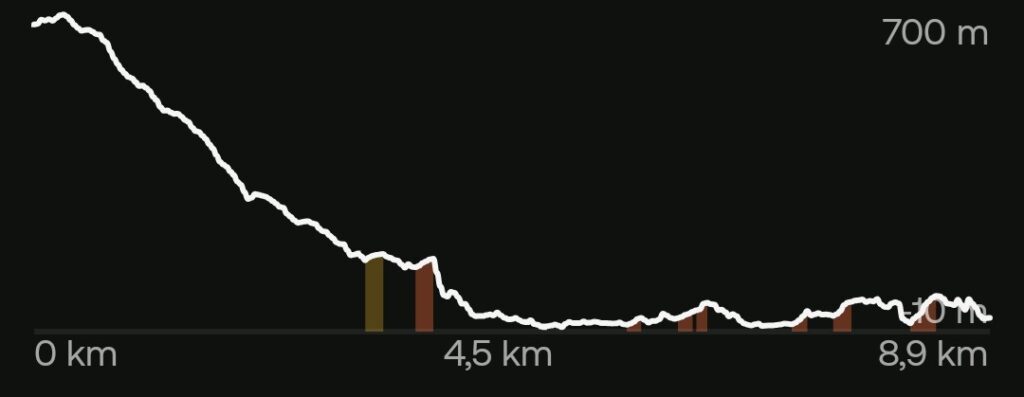
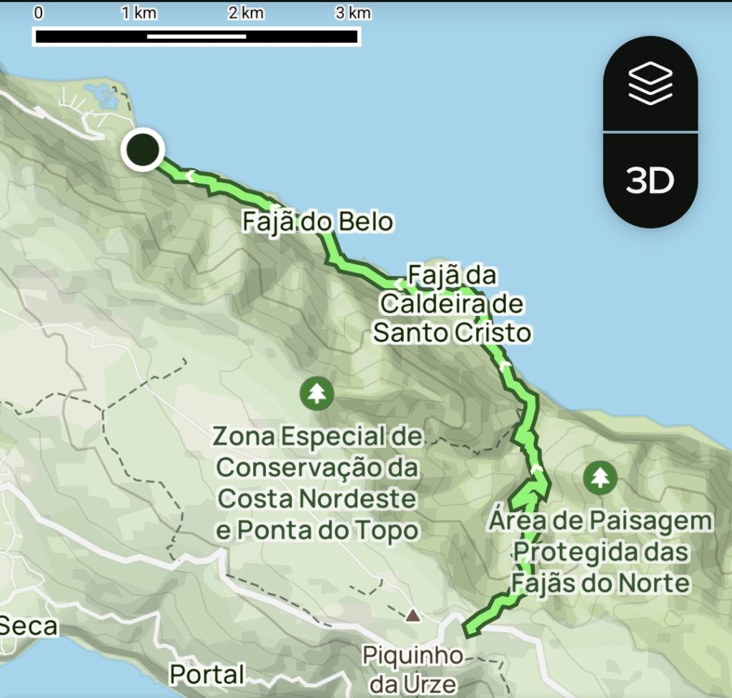
This official trail (PR01SJ) is classified within the scope of the Natura 2000 Network, São Jorge Natural Park, and the UNESCO Biosphere Reserve – Fajãs de São Jorge. It crosses Ecological and Conservation Zones within the Protected Area for Habitat or Species Management of Pico da Esperança and the Central Plateau, the Protected Landscape of Caldeira de Santo Cristo, and the Protected Area for Resource Management of the Fajãs Coast. It is also a Ramsar site (Protected Wetlands of International Importance) and a Geosite of the Azores UNESCO Global Geopark.
Triggered by a major earthquake (January 1, 1980) that destroyed access routes and left much of the steep north coast of São Jorge uninhabited, this trail was initially reopened after seismic activity caused collapses in several sections. It was restored to provide access to the old fajãs that became isolated and serves as a gateway to preserving both the natural and built landscape. It remains the only way to access these locations, preserving the original environment experienced by local populations and allowing visitors to understand how communities sustainably integrated and used natural resources.
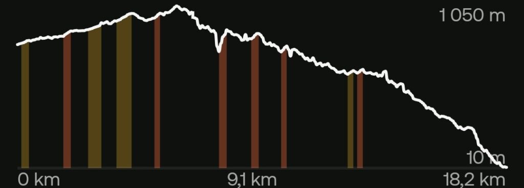
With an altitude difference of approximately 700 meters, this medium-difficulty linear trail stretches about 10 km, beginning at Serra do Topo. It crosses various ecological niches where endemic species of fauna and flora can be observed, along with diverse geological formations, watercourses, permanent streams, and waterfalls. At a certain point, the mountain path transitions along the cliff that provides access to the Fajãs of Santo Cristo and Cubres — undoubtedly among the most famous not only on São Jorge but throughout the entire archipelago.
These fajãs are the result of a powerful earthquake that struck this area in 1757. Combined with the erosion of rocky escarpments, it created coastal platforms and a unique debris fajã ecosystem formed by cliff erosion. Nearby is a small underground cave adjacent to the famous Lagoon of Fajã da Caldeira de Santo Cristo, which together with the Lagoon of Fajã dos Cubres forms the only coastal lagoon system in the Azores.
Fajã da Caldeira de Santo Cristo is a place of rare and lush scenic beauty, notable both for its landscape and ecological importance.
During this route, it is possible to enjoy a waterfall, lagoon, or sea swim, so bringing appropriate equipment is recommended.
Clothing and Equipment
In addition to swim gear, it is recommended to bring a cap, a comfortable backpack (not exceeding 25L), suitable hiking footwear (preferably waterproof, as the terrain and vegetation may be damp even when it is not raining), light wind and rain protection (it is possible to experience four seasons in one day), and a camera.Category – Linear
Difficulty – Medium
Distance – 9.3 km
Hiking Time – 2h 30
Activity Duration – 3h 30
Road Book – Trail Serra do Topo – Fajã dos Vimes (PR02SJ)


Price – from €140 per group (with transport), depending on group size
From €180 per group (with transport) when combined with:
- Road Book – Trail Fajã dos Vimes – Lourais – Fajã de São João (PR03SJ), or
- Road Book – Trail Fajã dos Vimes – Fragueira – Portal (PR09SJ)
Includes
- Transport and Activity insurance
- Certified Nature Guide with a university degree in Environmental Sciences
- Transport to and from Accommodation, Airport, or Ports
- Water
- Snack
Description – Trail Information
This official trail (PR02SJ) is classified within the Natura 2000 Network, São Jorge Natural Park, the UNESCO Biosphere Reserve – Fajãs de São Jorge, and the Protected Area for Habitat or Species Management of the South Coast. It also crosses Ecological and Conservation Zones within the Protected Area for Habitat or Species Management of Pico da Esperança and the Central Plateau. It is a Geosite of the Azores UNESCO Global Geopark.
With an altitude difference of approximately 700 meters, this difficult linear trail stretches about 5.5 km and crosses diverse ecological niches, ranging from High-Altitude Wetlands to Coastal Wetlands, Seagrass Meadows, and Coastal Cliff Areas.
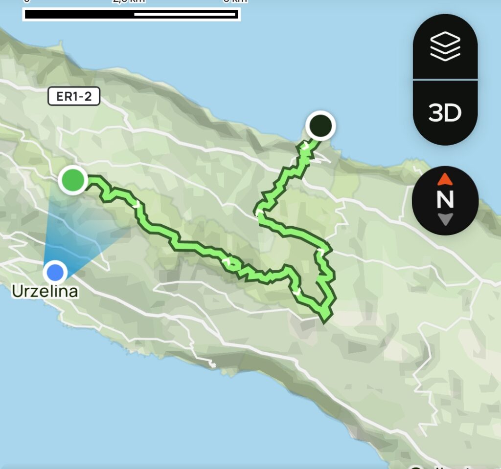
Connecting Serra do Topo to Fajã dos Vimes, this is an ancient trail once used by traditional communities to link the coastal Fajã dos Vimes with the higher-altitude areas of Serra do Topo, including farmland and firewood collection areas, as well as providing access to the island’s north coast.
This route is particularly notable for its steep slopes and sharp descent along the cliff toward the coast. Along the way, hikers pass through various ecological niches shaped by diverse microclimates, permanent water streams, and natural springs of drinking water in a short but demanding route.
The trail ends at Fajã dos Vimes, whose name derives from the former production of wicker (used for basket weaving). It is a small fajã with strong agricultural and artisanal traditions, recognized for producing its exclusive coffee, which visitors can taste, as well as for its handicraft house featuring traditional quilts.
Upon arrival at Fajã dos Vimes, it is also possible to enjoy a sea swim, so bringing appropriate equipment is recommended.
Clothing and Equipment
In addition to swim gear, it is recommended to bring a cap, a comfortable backpack (not exceeding 25L), suitable hiking footwear (preferably waterproof, as the terrain and vegetation may be damp even when it is not raining), light wind and rain protection (it is possible to experience four seasons in one day), and a camera.Category – Linear
Difficulty – Difficult
Distance – 5.5 km
Hiking Time – 2h
Total Duration – 3h
Road Book – Trail Fajã dos Vimes – Lourais – Fajã de São João (PR03SJ)
Price – from €180 per group (with transport), depending on group size
For the same price, you may include:
- Road Book – Trail Serra do Topo – Fajã dos Vimes (PR02SJ), or
- Road Book – Trail Fajã dos Vimes – Fragueira – Portal (PR09SJ)
Includes
- Transport and Activity insurance
- Certified Nature Guide with a university degree in Environmental Sciences
- Transport to and from Accommodation, Airport, or Ports
- Water
- Snack
Description – Trail Information
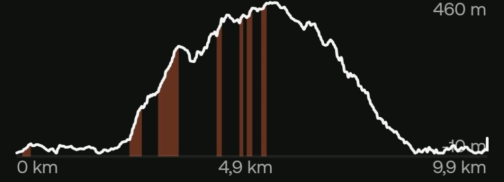
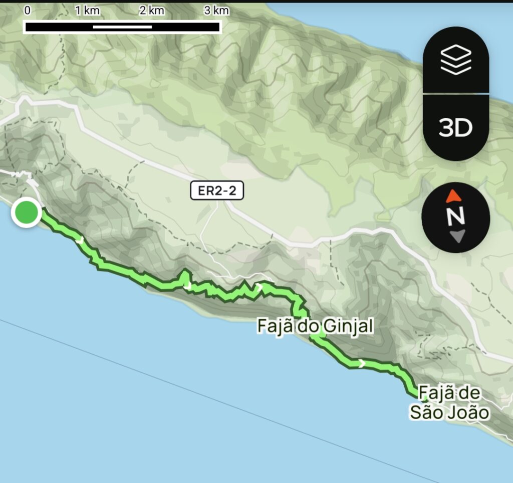
This official trail (PR03SJ) is classified within the Natura 2000 Network, the Protected Area for Habitat or Species Management of the South Coast, São Jorge Natural Park, and the UNESCO Biosphere Reserve – Fajãs de São Jorge.
This trail is part of the unique ecosystem of debris fajãs — coastal platforms formed by cliff erosion. Due to its geological nature, special caution is required when planning the hike during or after periods of heavy rainfall, as it crosses several water resources such as small streams and waterfalls that may make passage difficult or even impossible.
Beyond its heritage, ecological, and geomorphological value — as it follows the transition between the sheltered environment of the fajãs and the mid-altitude slopes along the steep coastline, offering breathtaking views — this very ancient trail also holds strong cultural significance. It reveals how traditional communities moved through the landscape and sustainably used natural resources, illustrating seasonal migratory movements between settlements at sea level and at higher altitudes, known as “mudas.”
Beginning at Fajã dos Vimes — whose name derives from the historical production of wicker used in basket weaving and which has strong agricultural and artisanal traditions, recognized for its exclusive coffee and traditional quilts — the trail ends at Fajã de São João, a small community renowned for its well-preserved vernacular and traditional architecture.
Along the way, it also passes through nearly uninhabited small fajãs such as Bodes and Ginjal, as well as Lourais, a small rural settlement at higher altitude, known for its famous cheese.
During this trail, it is also possible to enjoy a sea swim or cool off in one of the many waterfalls or streams, so bringing appropriate equipment is recommended.
Clothing and Equipment
In addition to swim gear, it is recommended to bring a cap, a comfortable backpack (not exceeding 25L), suitable hiking footwear (preferably waterproof, as the terrain and vegetation may be damp even when it is not raining), light wind and rain protection (it is possible to experience four seasons in one day), and a camera.Category – Linear
Difficulty – Difficult
Distance – 9.6 km
Hiking Time – 3h 30
Total Duration – 4h 30
Road Book – Trail Pico do Pedro – Pico da Esperança – Fajã do Ouvidor (PR04SJ)
Price – from €180 per group (with transport), depending on group size
Includes
- Transport and Activity insurance
- Certified Nature Guide with a university degree in Environmental Sciences
- Transport to and from Accommodation, Airport, or Ports
- Water
- Snack
Description – Trail Information
This official trail (PR04SJ) is classified within the Natura 2000 Network, the Special Area of Conservation of the Northwest Coast and Ponta do Topo, crossing Ecological and Conservation Zones within the Protected Area for Habitat or Species Management of Pico da Esperança and the Central Plateau, São Jorge Natural Park, and the UNESCO Biosphere Reserve – Fajãs de São Jorge. It is also a Ramsar site known as the Central Plateau of São Jorge (Protected Wetlands of International Importance) and a Geosite of the Azores UNESCO Global Geopark.
This trail begins at altitude, near the base of Pico do Pedro, in the central area of the island, along a mountain ridge composed of different tectonic and volcanic alignments. It includes several inland lagoons of high geological and ecological value, successive volcanic cones, high-altitude peat bogs, and mountain pastures. A highlight is the passage by Pico da Esperança, the highest point on the island, where it is possible to observe the sea and all surrounding islands.
This unique ecosystem favors the occurrence of various endemic species, some of them rare, such as the rarest orchid in Europe, Platanthera azorica.
This linear trail, of medium difficulty and 17 km in length — much of it between 800 and 1000 meters in altitude — should preferably be planned for days with good weather and clear visibility. From this mountain ridge, a gradual descent begins toward the north coast, passing through green slopes, water lines, and increasingly sheltered forest areas. The dramatic cliff-lined north coast gradually reveals itself, accompanied by the growing sound of the sea along which former magma flows descended. The deposits formed near the ocean gave rise to Fajã do Ouvidor, where the trail ends.
Due to the significant volcanic process that shaped Fajã do Ouvidor, it has the only sheltered harbor on the north coast, a bathing area, and a series of natural basalt-formed pools. Among them stands out the iconic Poça Simão Dias, inviting visitors for a swim and relaxation.
Clothing and Equipment
In addition to swim gear, it is recommended to bring a cap, a comfortable backpack (not exceeding 25L), suitable hiking footwear (preferably waterproof, as the terrain and vegetation may be damp even when it is not raining), light wind and rain protection (it is possible to experience four seasons in one day), and a camera.Category – Linear
Difficulty – Medium
Distance – 17 km
Hiking Time – 5 h
Total Duration – 6 h
Road Book – Trail Fajã do Além (PRC05SJ)
Price – from €160 per group (with transport), depending on group size
Includes
- Transport and Activity insurance
- Certified Nature Guide with a university degree in Environmental Sciences
- Transport to and from Accommodation, Airport, or Ports
- Water
- Snack
Description – Trail Information
This official trail (PRC05SJ) is classified within the Natura 2000 Network, the Protected Area for Habitat or Species Management, São Jorge Natural Park, and the UNESCO Biosphere Reserve – Fajãs de São Jorge.
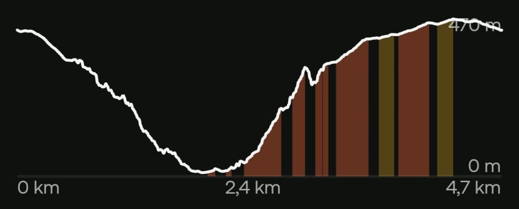
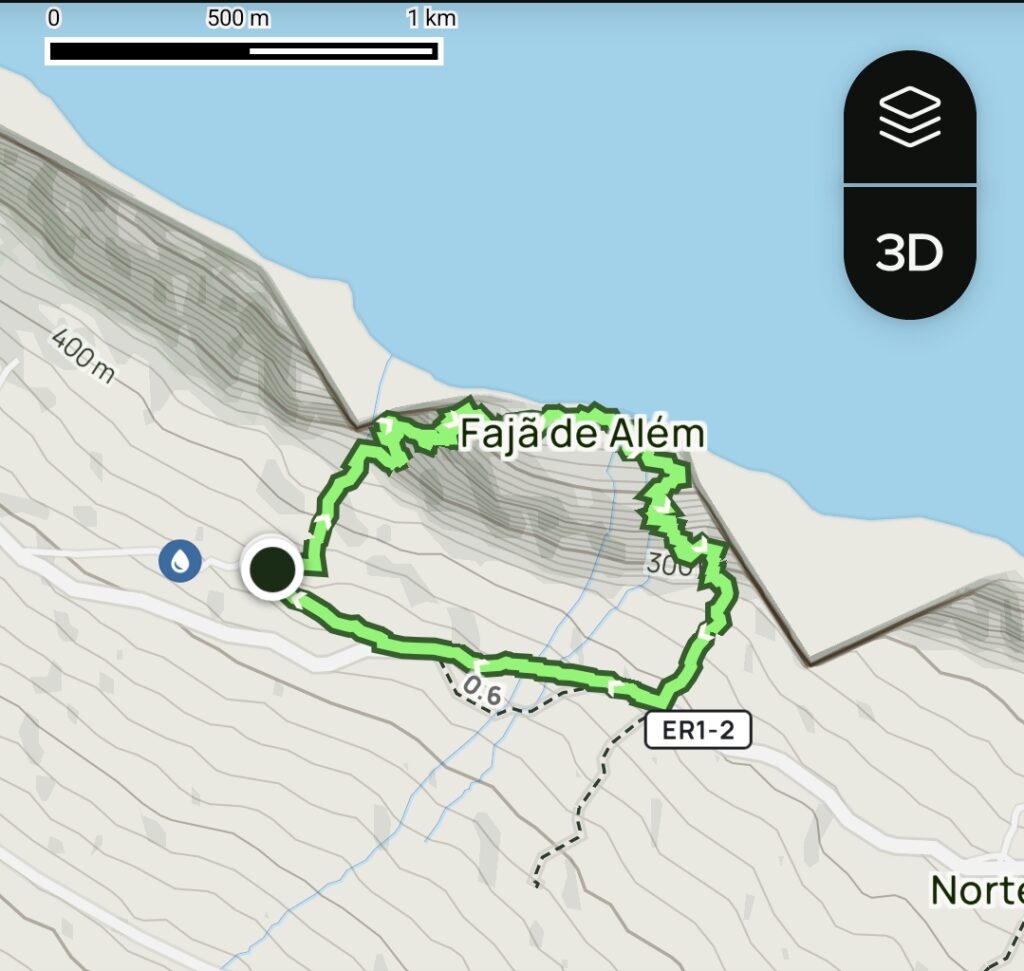
This circular route, approximately 5 km in length and of difficult difficulty, begins and ends near the Chapel of Santo António, located at altitude on the north coast, adjacent to the tectonic cliff that surrounds it and from which the steep outline leading down to Fajã do Além is revealed.
Beyond its heritage, ecological, and geomorphological value — as it follows the transition between the mid- to high-altitude slopes of the mountain range along the rugged coastline and the sheltered environment of the fajã — this very ancient trail also holds significant cultural importance. It reveals how traditional communities moved through the landscape and sustainably used natural resources, describing the seasonal migratory movements between settlements at sea level and at higher altitudes, known as “mudas.”
Due to the abrupt nature of the cliff along the access route to and from Fajã do Além, hikers can enjoy breathtaking views while crossing several streams, waterfalls, and natural springs, where pure water can be seen emerging directly from the rock.
Fajã do Além, as this trail is its only access and given its level of difficulty, is considered one of the best-preserved fajãs. Its sense of isolation and tranquility reflects its strong connection to traditional vineyard and yam cultivation, preserving ancestral architectural features such as small family-use wine cellars. Along the route, hikers pass through areas of natural vegetation and former agricultural lands where livestock enclosures, wine cellars, and small support structures for farming activities still remain.
Clothing and Equipment
In addition to swim gear, it is recommended to bring a cap, a comfortable backpack (not exceeding 25L), suitable hiking footwear (preferably waterproof, as the terrain and vegetation may be damp even when it is not raining), light wind and rain protection (it is possible to experience four seasons in one day), and a camera.Category – Circular
Difficulty – Difficult
Distance – 4.7 km
Hiking Time – 2h 30
Total Duration – 3h 30
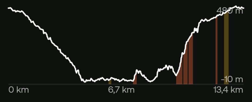
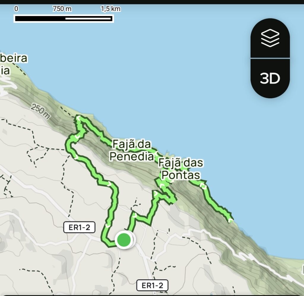
Road Book – Trail Norte Pequeno / Fajãs – Mero – Penedia – Pontas (PRC06SJ)
Price – from €180 per group (with transport), depending on group size
Includes
- Transport and Activity insurance
- Certified Nature Guide with a university degree in Environmental Sciences
- Transport to and from Accommodation, Airport, or Ports
- Water
- Snack
Description – Trail Information
This official trail (PRC06SJ) is classified within the Natura 2000 Network. It crosses Ecological and Conservation Zones of the Protected Landscape Area of the Fajãs do Norte, São Jorge Natural Park, and the UNESCO Biosphere Reserve – Fajãs de São Jorge. It is also a Ramsar site (Protected Wetlands of International Importance) and a Geosite of the Azores UNESCO Global Geopark.
This circular route, approximately 11 km long and of medium difficulty, begins and ends near the Parish Council of Norte Pequeno, a small rural parish located at altitude on the north coast, adjacent to the tectonic cliff that surrounds it. From here, the steep outline leading down to the Fajãs of Mero, Penedia, and Pontas becomes visible. The first two are debris fajãs, while the latter is one of the rare fajãs formed by magma flow on the north coast.
This area is characterized by high, rugged cliffs where successive landslides created fertile coastal platforms, seasonally occupied by local communities.
These fajãs, of great ecological, scenic, and cultural value, stand out for their vernacular and traditional architecture. They are part of the short seasonal migratory movements between settlements at sea level and at higher altitudes — known as “mudas” — revealing how traditional populations moved across the landscape and sustainably used natural resources. They preserve a strong connection to traditional agriculture and viticulture, with their wine cellars and ancestral architectural features.
Due to the abrupt geological nature of the access routes to and from the fajãs, hikers can enjoy breathtaking views over the ocean and the cliffs, reinforcing the sensation of walking within a true natural amphitheater.
During this trail, there is a small harbor and several points where it is possible to enjoy a refreshing sea swim, so bringing appropriate equipment is recommended.
Clothing and Equipment
In addition to swim gear, it is recommended to bring a cap, a comfortable backpack (not exceeding 25L), suitable hiking footwear (preferably waterproof, as the terrain and vegetation may be damp even when it is not raining), light wind and rain protection (it is possible to experience four seasons in one day), and a camera.Category – Circular
Difficulty – Medium
Distance – 10.9 km
Hiking Time – 3h 30
Total Duration – 4h
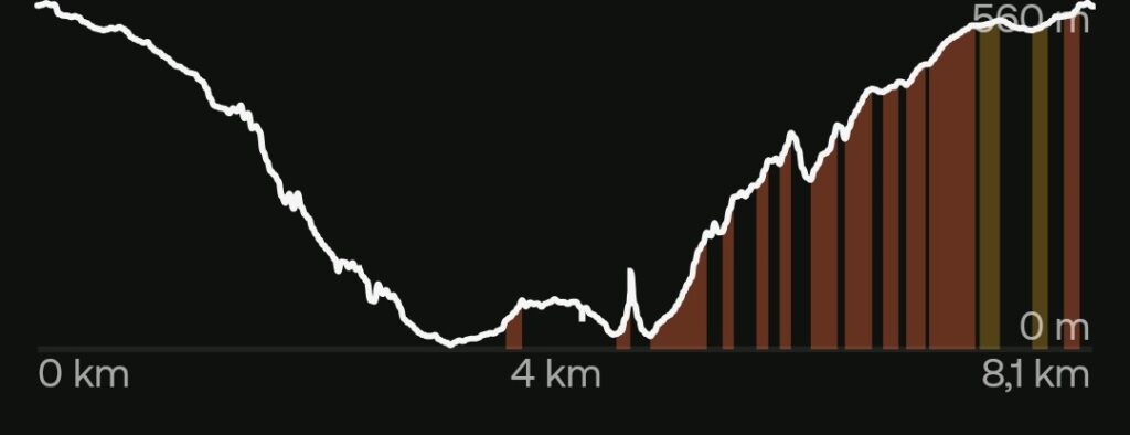
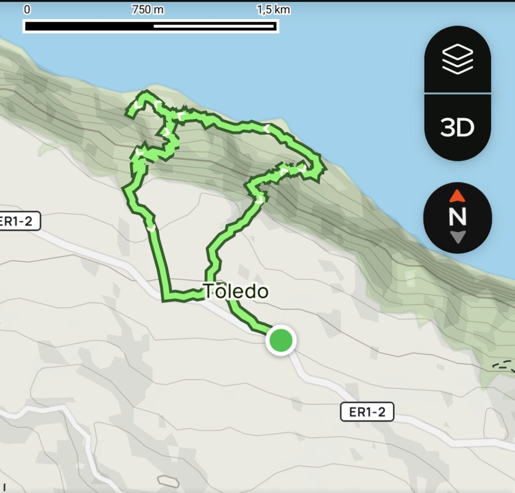
Road Book – Fajãs do Toledo – Manuel Martins – Rasa – Vasco Martins (PRC08SJ)
Price – from €180 per group (with transport), depending on group size
Includes
- Transport and Activity insurance
- Certified Nature Guide with a university degree in Environmental Sciences
- Transport to and from Accommodation, Airport, or Ports
- Water
- Snack
Description – Trail Information
This official trail (PRC08SJ) is classified within the Natura 2000 Network, the Protected Area for Habitat and Species Management of the Northwest Coast, São Jorge Natural Park, and the UNESCO Biosphere Reserve – Fajãs de São Jorge. It is also included in the Important Bird and Biodiversity Area (IBA).
This difficult circular route, approximately 7 km long, begins and ends near the 19th-century Chapel of São José in Toledo, a small rural parish located at altitude on the north coast, adjacent to the tectonic cliff that surrounds it. From here, the steep outline leading down to the remote fajãs of Manuel Martins, Rasa, and Vasco Martins is revealed, offering panoramic views over the north coast.
This area is characterized by high, rugged cliffs where successive landslides created fertile coastal platforms traditionally occupied seasonally by local communities. However, these fajãs were progressively abandoned after the 1980 earthquake. Only recently was this trail restored, making these fajãs some of the most emblematic representations of traditional ways of life. Vestiges of vernacular architecture remain, including houses, wine cellars, agricultural support structures, and terraced stone fields harmoniously integrated with the mountain slopes and the outline of the sea.
Along this trail, hikers pass through diverse ecological niches rich in endemic vegetation and marked by a variety of microclimates, with permanent watercourses, freshwater springs, and waterfalls. The largest and most emblematic is Poço da Airoses waterfall, where eels were traditionally caught and where it is possible to enjoy a refreshing swim.
Between the fajãs, it is also possible to access the coastline and enjoy a sea swim. However, as throughout this route, access points are difficult and physically demanding, so the necessary equipment must be carried accordingly.
Clothing and Equipment
In addition to swim gear, it is recommended to bring a cap, a comfortable backpack (not exceeding 25L), suitable hiking footwear (preferably waterproof, as the terrain and vegetation may be damp even when it is not raining), light wind and rain protection (it is possible to experience four seasons in one day), and a camera.Category – Circular
Difficulty – Difficult
Distance – 6.9 km
Hiking Time – 3 h
Total Duration – 4 h
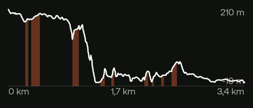
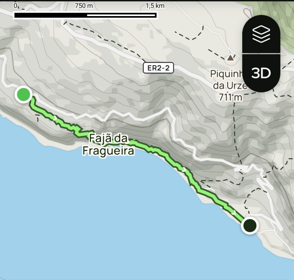
Road Book – Trail Portal – Fajã da Fragueira – Fajã dos Vimes (PR09SJ)
Price – from €120 per group (with transport), depending on group size
From €180 per group (with transport) when combined with:
- Road Book – Trail Serra do Topo – Fajã dos Vimes (PR02SJ), or
- Road Book – Trail Fajã dos Vimes – Lourais – Fajã de São João (PR03SJ)
Includes
- Transport and Activity insurance
- Certified Nature Guide with a university degree in Environmental Sciences
- Transport to and from Accommodation, Airport, or Ports
- Water
- Snack
Description – Trail Information
This official trail (PR09SJ) is classified within the Natura 2000 Network, the Protected Area for Habitat or Species Management, São Jorge Natural Park, and the UNESCO Biosphere Reserve – Fajãs de São Jorge.
This linear route, of medium difficulty and just over 3 km in length, begins at Portal — which, as its name suggests, was historically the access point to the steep coastal escarpment. It connected a mesic mid-altitude area, linking the larger parish of Ribeira Seca to the fajãs located along the rocky cliff by the sea. These fajãs, formed by magma flows or coastal erosion, created flat and fertile surfaces with their own microclimates suitable for cultivation and habitation.
Beyond its heritage, ecological, and geomorphological value — as it follows the transition between the sheltered environment of the fajãs and the mid-altitude slopes along the steep coastline, offering breathtaking views — this very ancient trail is also of great cultural interest. It reveals how traditional communities moved through the landscape and sustainably used natural resources, illustrating the seasonal migratory movements between settlements at sea level and at higher altitudes, known as “mudas.”
The trail ends at Fajã dos Vimes, whose name derives from the former production of wicker used in basket weaving. It is a small fajã with strong agricultural and artisanal traditions, recognized for producing its exclusive coffee — which visitors can taste — as well as for its handicraft house featuring traditional quilts.
Upon arrival at Fajã dos Vimes, it is also possible to enjoy a sea swim, so bringing appropriate equipment is recommended.
Clothing and Equipment
In addition to swim gear, it is recommended to bring a cap, a comfortable backpack (not exceeding 25L), suitable hiking footwear (preferably waterproof, as the terrain and vegetation may be damp even when it is not raining), light wind and rain protection (it is possible to experience four seasons in one day), and a camera.Category – Linear
Difficulty – Medium
Distance – 3.1 km
Hiking Time – 1h 30
Total Duration – 2 h
F.A.Q.
Let's try and help
You can travel by plane or ferry boat, please check SATA Airlines and Atlantic Azores.
Reach out using our Contact page.
Yes, you can reach during your booking and ask for a transfer service, airport or harbour.
Yes, we do offer customized guided tour and more with professional nature guides.
Yes. Contact us!